A project successfully completed:
« Elaboration of natural risk maps and detailed risk plans for landslides for a number of administrative-territorial units of Prahova County».
And a new beginning: « Making the first geotechnical risk map in Romania ».
Eng. Emil Oltean – Head of geotechnical department – SC Geostud SRL
Geographer Alina Eftimie – SC Geostud SRL
Eng. Vali Niță – SC Geostud SRL
 At the beginning of June 2019, the last stage regarding the realization of the natural risk maps and the detailed risk plans for landslides was notified by the Ministry of Regional Development and Public Administration for a number of 22 territorial administrative units belonging to the Prahova County. Thus ended a process started in 2011, where, during 5 stages, a team led by the project manager Alina Eftimie, made the plans for this natural risk, for 71 territorial and administrative division (t.a.d.) located in the north and center of Prahova county.
Although for the 71 t.a.d-s the were individual projects, they were realized respecting the methodology provided in “HG 447/2003 for approving the methodological norms regarding the elaboration and the content of the natural risk maps for landslides and floods”, in order to could be integrated into the structure of the study of the natural risk areas identification for landslides at county level.
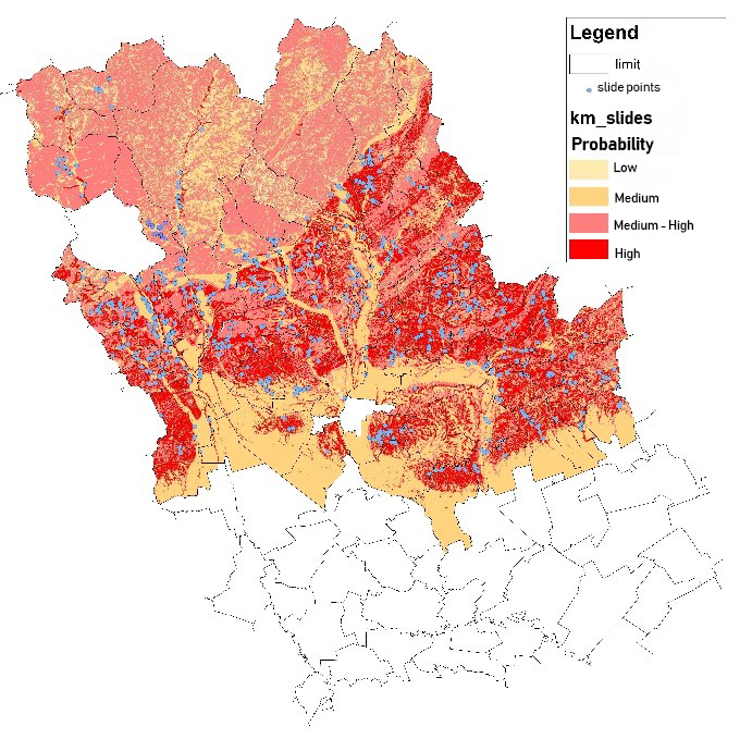
All the projects were realized in an integrated GIS (Geographic Information System) system, thus making available to the Prahova County Council not only the hazard and risk maps for landslides (figure 1), the thematic maps, which according to the HG 447/2003, which were the basis of their realization (lithological factor map, geomorphological map – figure 2, climatic and hydrogeological map, forest map, etc.), but also a large database containing:
• Detailed records for each of the 687 landslides distributed over the 71 t.a.d-s lands, containing: the location of the slip (in geographical coordinates and STEREO 70), the limits of the slip, the description of the slide with representative photos, remediation solutions, etc.)
• Infrastructure network (road and rail transport, sewage, telephony, cable, etc.), georeferenced and digitized for all the analyzed t.a.d-s;
• The hydrographic network (all cadastral and non-cadastral rivers, torrential valleys, artificial and natural lakes) georeferenced and digitized.
Starting from this experience, in which SC GEOSTUD SRL carried out the geotechnical and geophysical research, and in front of a new project that aims to analyze the geotechnical risk factors on an area, on which it is desired to realize a new railway route, it was conceived a new map model, this time based on the criteria for defining the geotechnical risk (according to NP 074/2014. Normative regarding the geotechnical documentation for constructions) -table 1.
Table 1 Factors for defining the geotechnical risk , Classification and Score
1.Field conditions
Good terrains-2 Score Medium terrain-3 Score Difficult terrain-6 Score
2. Groundwater
Without dewatering-1 Score With normal dewaterings- 2 Score With exceptional dewaterings-4 Score
3. Neighborhood
No risks-1 Score Moderate risks-3 Score Major risks-4 Score
4.Category of importance
Low-2 Score Normal-3 Score Special, exceptional-5 Score
5. Neighborhood
No risks-1 Score Moderate risks-3 Score Major risk-4 Score
6. Seismic zone
Areas with ag=0.25g-3 Score Areas with ag=(0.15…0.25)g-2 Score Areas with ag<0.15 g-1 Score
Table 2
Score limits Geotechnical category Geotechnical risk
6 – 9 1 low
10 – 14 2 moderate
15 – 22 3 major
For the realization of this new map model, the principles of HG 447 have been preserved by defining layers (thematic maps) based on which, through a calculation algorithm, to reach the final product: the geotechnical risk map. The 5 layers used were represented by the factors that define the geotechnical risk, and the score given to each factor was the one specified in NP 074/2014.
Previously, in the area of interest, a geological-technical mapping was performed, an action that represents a sine-qua-non condition, for the realization of the geotechnical risk map.
Also, before making the geotechnical risk map, we made, on the same area, the hazard map for landslides, first to calibrate the two models, but also because they include common elements (for example the digital model of the land).
Thus, for the definition of the terrain conditions, the available geological maps were used, supplemented with the information obtained from the geological-technical mapping.
For zoning “landslides with slip potential”, classified in NP 074 under “terrain conditions” as “difficult lands”, we used the slopes map obtained on the basis of the digital terrain model. A limitation of the normative NP074 / 2014, which lacks a geomorphological and hydrological criterion (surface terrain conditions) in defining the “geotechnical risk”, however, forced us to frame the terrain slope the “terrain conditions” layer thus sharing the points.
- To define the dewatering we used the hydrogeological map of the area, drawn up by IGR (scale 1: 100000) but also the data obtained from the field observations.
- Construction importance category: in our case being an important railway line, the construction importance category is “special, exceptional”.
- Neighborhoods were defined by the urban boundaries of the territorial administrative divisions, the former mining perimeters in the study area, the protected areas or the infrastructure networks (transport, communications, etc.).
- The seismic zone was established on the basis of the “Seismic Design Code – part 1 – Design provisions for buildings, indicative P100-1 / 2013” – the map of the peak values of the acceleration of the terrain for design (ag).
Finally, the geotechnical risk map was obtained by combining the 5 thematic maps, with the help of the ArcMap program, summing the scores related to each factor and zoning according to the limits of the scores in table 2.
In the figures below are presented both “hazard map for landslides” (figure 2) made according to HG 447/2003 and “geotechnical risk map” (figure 3) obtained according to the methodology described above.
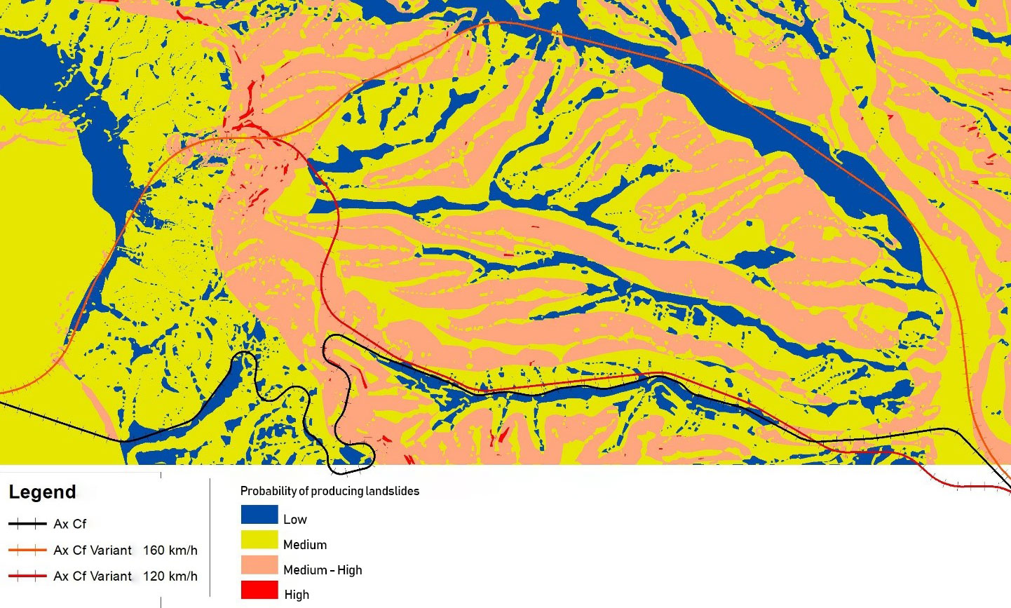
Figure 2. The hazard map for landslides of the area of interest
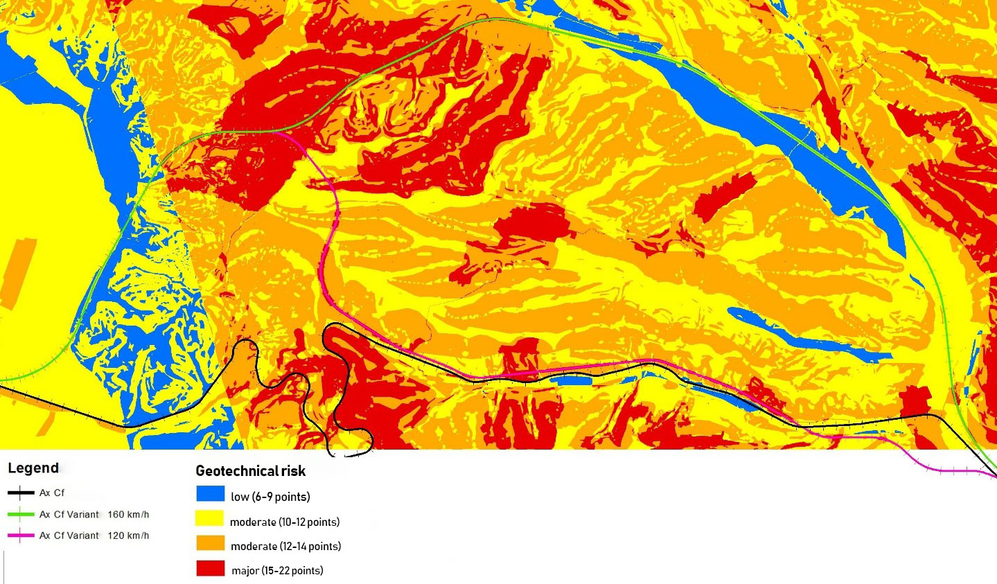
Figure 3. Geotechnical risk map
After the completion of the two maps and from their analysis we can conclude:
- The geotechnical risk map represents a qualitative leap from the hazard map to landslides, because in its realization were included not only the natural hazards related to the land (landslides and earthquakes), but also the other elements (belonging both to the terrain conditions as well as the project) that can induce geotechnical risks in the relation of the future structures with the foundation ground.
- The geotechnical risk map could be extremely useful not only in the incipient phases of a project (prefeasibility), in the multicriteria analysis of the choice of new variants of the transport infrastructure route (highways, express roads, railways, etc.), but also in the phases in which the geotechnical studies are required (feasibility study, technical project), the volume and type of geotechnical investigations can be dimensioned based on such a map.
- An eventual methodological Norm for the realization of the geotechnical risk map should be accompanied by an update of the “Normative regarding the geotechnical documentation for constructions – NP 074/2014” because, the lack of a “geomorphological, hydrological” criterion for defining the geotechnical risk it influences not only the mapping of the geotechnical risk map, but also often the constructions designed under difficult terrain conditions, (erosion zones, torrential valleys, areas exposed to floods, etc.).
BIBLIOGRAPHY:
• Normative regarding the geotechnical documentation for constructions – indicative NP 074/2014
• Seismic design code – Part 1 – “Prevederi de proiectare pentru clădiri indicativ P100-1/2013”
• Guide on the assessment of the risk associated with landslides in the road area – AND 594/2013
• GIS Fundamentals: A First Text on Geographic Information Systems, Fifth Edition 5th edition Edition, by Paul Bolstad (Author)
• Introduction to Geographic Information Systems: Hardcover – 2015, by Kang-tsung Chang (Author)
• Designing Better Maps: A Guide for GIS Users Second Edition, by Cynthia A. Brewer (Author)
• Imagery and GIS: Best Practices for Extracting Information from Imagery 1st Edition, by Kass Green (Author), Russell G. Congalton (Author), Mark Tukman (Author)
• Cartography: Thematic Map Design 6th Edition, by Borden D Dent (Author), Jeff Torguson (Author), Thomas W. Hodler (Author)
• Making Spatial Decisions Using GIS and Lidar: A Workbook 1st Edition, by Kathryn Keranen (Author), Robert Kolvoord (Author)